iOS开发之MapKit框架的使用
文/Corwien
一、MapKit框架使用前提
1、导入框架
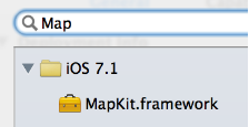
2、导入主头文件
#import
MapKit框架使用须知:
-
MapKit框架中所有数据类型的前缀都是MK
-
MapKit有一个比较重要的UI控件 :MKMapView,专门用于地图显示

二、跟踪显示用户的位置
设置MKMapView的userTrackingMode属性可以跟踪显示用户的当前位置
-
MKUserTrackingModeNone :不跟踪用户的位置
-
MKUserTrackingModeFollow :跟踪并在地图上显示用户的当前位置
-
MKUserTrackingModeFollowWithHeading :跟踪并在地图上显示用户的当前位置,地图会跟随用户的前进方向进行旋转
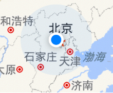
下图是跟踪效果:
-
蓝色发光圆点就是用户的当前位置
-
蓝色发光原点,专业术语叫做“大头针”
三、地图的类型
可以通过设置MKMapView的mapViewType设置地图类型
MKMapTypeStandard :普通地图(左图)
MKMapTypeSatellite :卫星云图 (中图)
MKMapTypeHybrid :普通地图覆盖于卫星云图之上(右图)

MKMapView的代理
MKMapView可以设置一个代理对象,用来监听地图的相关行为
常见的代理方法有
1、调用非常频繁,不断监测用户的当前位置
每次调用,都会把用户的最新位置(userLocation参数)传进来
- (void)mapView:(MKMapView *)mapView didUpdateUserLocation:(MKUserLocation *)userLocation;
2、地图的显示区域即将发生改变的时候调用
- (void)mapView:(MKMapView *)mapView regionWillChangeAnimated:(BOOL)animated;
3、地图的显示区域已经发生改变的时候调用
- (void)mapView:(MKMapView *)mapView regionDidChangeAnimated:(BOOL)animated;
MKUserLocation
MKUserLocation其实是个大头针模型,包括以下属性
①、显示在大头针上的标题
@property (nonatomic, copy) NSString *title;
②、显示在大头针上的子标题
@property (nonatomic, copy) NSString *subtitle;
③、地理位置信息
@property (readonly, nonatomic) CLLocation *location;
四、设置地图的显示
通过MKMapView的下列方法,可以设置地图显示的位置和区域
设置地图的中心点位置
@property (nonatomic) CLLocationCoordinate2D centerCoordinate; - (void)setCenterCoordinate:(CLLocationCoordinate2D)coordinate animated:(BOOL)animated;
设置地图的显示区域
@property (nonatomic) MKCoordinateRegion region; - (void)setRegion:(MKCoordinateRegion)region animated:(BOOL)animated; MKCoordinateRegion MKCoordinateRegion是一个用来表示区域的结构体,定义如下 typedef struct { CLLocationCoordinate2D center; // 区域的中心点位置 MKCoordinateSpan span; // 区域的跨度 } MKCoordinateRegion; MKCoordinateSpan的定义
typedef struct { CLLocationDegrees latitudeDelta; // 纬度跨度 CLLocationDegrees longitudeDelta; // 经度跨度 } MKCoordinateSpan; 五、大头针
什么是大头针
现实生活中的大头针(左图)
地图上的大头针(右图)
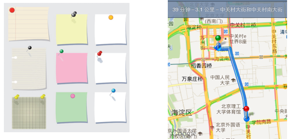
钉在某个具体位置,用来标识这个位置上有特定的事物(比如这个位置上有家餐馆)
大头针的基本操作
1.添加一个大头针
- (void)addAnnotation:(id)annotation;
2.添加多个大头针
- (void)addAnnotations:(NSArray *)annotations;
3.移除一个大头针
- (void)removeAnnotation:(id)annotation;
4.移除多个大头针
- (void)removeAnnotations:(NSArray *)annotations;
(id
大头针模型对象:用来封装大头针的数据,比如大头针的位置、标题、子标题等数据
大头针模型
新建一个大头针模型类
#import@interface MJTuangouAnnotation : NSObject /** 坐标位置 */ @property (nonatomic, assign) CLLocationCoordinate2D coordinate; /** 标题 */ @property (nonatomic, copy) NSString *title; /** 子标题 */ @property (nonatomic, copy) NSString *subtitle; @end
添加大头针
MJTuangouAnnotation *anno = [[MJTuangouAnnotation alloc] init]; anno.title = @"广州荔湾"; anno.subtitle = @“白天鹅宾馆欢迎您"; anno.coordinate = CLLocationCoordinate2DMake(80, 166); [self.mapView addAnnotation:anno];
自定义大头针
很多情况下,需要自定义大头针的显示样式,比如显示一张图片
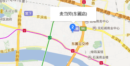
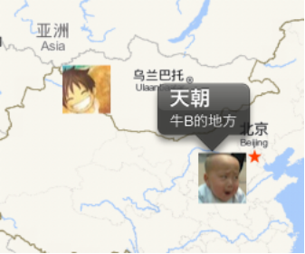
如何自定义大头针
设置MKMapView的代理
实现下面的代理方法,返回大头针控件
- (MKAnnotationView *)mapView:(MKMapView *)mapView viewForAnnotation:(id)annotation;
根据传进来的(id
代理方法的使用注意:
-
如果返回nil,显示出来的大头针就采取系统的默认样式
-
标识用户位置的蓝色发光圆点,它也是一个大头针,当显示这个大头针时,也会调用代理方法
因此,需要在代理方法中分清楚(id
示例:
- (MKAnnotationView *)mapView:(MKMapView *)mapView viewForAnnotation:(id)annotation { // 判断annotation的类型 if (![annotation isKindOfClass:[MJTuangouAnnotation class]]) return nil; // 创建MKAnnotationView static NSString *ID = @"tuangou"; MKAnnotationView *annoView = [mapView dequeueReusableAnnotationViewWithIdentifier:ID]; if (annoView == nil) { annoView = [[MKAnnotationView alloc] initWithAnnotation:annotation reuseIdentifier:ID]; annoView.canShowCallout = YES; } // 传递模型数据 annoView.annotation = annotation; // 设置图片 MJTuangouAnnotation *tuangouAnnotation = annotation; annoView.image = [UIImage imageNamed:tuangouAnnotation.icon]; return annoView; }
MKAnnotationView
地图上的大头针控件是MKAnnotationView
MKAnnotationView的属性
1、大头针模型
@property (nonatomic, strong) idannotation;
2、显示的图片
@property (nonatomic, strong) UIImage *image;
3、是否显示标注
@property (nonatomic) BOOL canShowCallout;
4、标注的偏移量
@property (nonatomic) CGPoint calloutOffset;
5、标注右边显示什么控件
@property (strong, nonatomic) UIView *rightCalloutAccessoryView;
6、标注左边显示什么控件
@property (strong, nonatomic) UIView *leftCalloutAccessoryView;
MKPinAnnotationView
MKPinAnnotationView是MKAnnotationView的子类
MKPinAnnotationView比MKAnnotationView多了2个属性
大头针颜色
@property (nonatomic) MKPinAnnotationColor pinColor;
大头针第一次显示时是否从天而降
@property (nonatomic) BOOL animatesDrop;
完整示意图:



![[HBLOG]公众号](https://www.liuhaihua.cn/img/qrcode_gzh.jpg)

